Sunday, August 26, 2007

Kalhatti falls

This trek happened some time back (a reliable source tells me it was on the 26th of August of 2007). Well, lets assume its true. Actually a night trek to Kalavarabetta was being planned for that weekend but for some forgotten reason, Kalavarabetta didn't happen. Everything happens for the good. Sriram wanted to do some 'serious' trek and we were off to Bababudangiri on the evening of 25th from Bangalore in a TT.The team: Sriram, Vachan, Subbu, yours truly, Flavia, Reshma, Hakim, Vinod, Ananth, Moch and Paddy (not in this pic).

The route: Bangalore-Hassan-Chickmagalur-Bababudangiri.The journey from Bangalore to BBGiri was quite uneventful. Few slept and for the other nocturnals, "KurigaLu Saar KurigaLu" (a really funny kannada movie) was being played.

Reached BBGiri at around 6 in the morning and even our asses were shivering there. Finishing morning rituals, we went to the only "restaurant" there which served good Bread Omlette. Be warned that the pure veggies dont have many options in BBGiri. Subbu, the eternal waste fellow, didn't happen to recharge his camera batteries, and to top it, took 100+ snaps inside the dingy looking place alone! Duh.


We had two trekking options: go to KemmanugunDi with a guide, or go to Kalhatti falls without a guide. Since some of us had done the BBGiri to KGundi route, we decided to go to Kalhatti falls. So what if no guide accompanied us? We had a GPS with all the points marked! Relying on the GPS, we first reached Galikere (lake of wind, wind lake, whatever), which is an awesome camping place (have camped there twice before). That was the third time I had been to the lake, and not once I could see the entire lake! Look at the foto and you'll know why. Even to go to KemmangunDi, you need to come to this place. From there on, we set off in another route towards Kalhatti falls. Light drizzle, awesome weather, beautiful landscapes, innumerable leeches... It was western ghats at it's best! Although we had a GPS and we knew which direction to head in, we could hardly see beyond 50 feet and we ended up using "brute-force" method to reach the destination. There might have been a clear-cut path but we ended up heading straight, into all the valleys and all the small peaks, unnecessarily! It came as no surprise to us when Subbu's batteries got exhausted within an hour into the trek. Bloody fellow! And although Moch did have a camera, he didn't even bother taking it out. No comments on that. It was around 5:30 in the evening when we finally reached the top of Kalhatti falls. Owing to good monsoons, the falls made for a good view from the top. It is a vertical drop of about 150 feet (or more, not sure). Since we were already late, we decided not to spend much time there and decided to get to the bottom where we had asked the TT to come to a village (kalhattigiri?).

Now began the fun. We could see a clear trail in front us to get down. But the GPS, the points to which were fed by PC, showed the next point to be somewhere above us, in a completely different direction. Confused, we saw where the point next to that was, and that happened to be in another different direction! More confused, we saw where the third point was.. and it showed to be in the direction we intended to go! But our committed man, Moch, decided to put all his faith on the GPS and went in the direction of the first point and then to second point, in that order. After about an hour and a half of climbing up and down, we realized we had come back to the same spot! Already dark (around 7 in the evening), wet to our undies, shivering, leeches having a feast on us, two torches for 11 people... I couldn't control myself and broke into a guffaw, all the while feeling sorry for our own foolishness! The next stretch of the trek was truly memorable. Steeep descent (real steep, I should say), loose mud, no real path in front of us, totally drenched... we weren't walking or crawling, we were sliding almost uncontrollably (lucky none of us got injured). I wasn't helped by the fact that the floaters I was wearing had absolutely flat soles :) Any part of my body I touched, I could pull out atleast a couple of leeches, blindly! After an hour of such descent, we reached a jeep track in a coffee estate, where we were not sure which direction of the track to go in. It was already past 8. So we decided to give our driver a call. Luckily he was reachable and we asked him to send some villagers for help :-). The villagers, to our dismay, told us over the phone that it would cost us 500 bucks! The ensuing conversation was quite funny:

We: Yenri Idu? Naavu kaLdu hogidivi illi. Help keLtha idivi. Neevu noDidre 500 rupai keLtha idiralla?

Villager: Illa ri, ashT agutte. Ee hothnalli naavu huDkonD barodu beDva?
We: Ree, 300 rupai thagoLLi hogli
Villager: Illa, 400 rupai
We: 350
Villager: 351...

Hehehe... After haggling for about 15 minutes, we settled for some amount (dont remember the exact amount) and within another 15 minutes, they reached us and helped us get back to civilization. After purging ourselves of all the leeches in all the unwanted places and changing to comfy, dry clothes, we headed back to Bangalore, stopping once for dinner at some arbit place.

Moral of the story:
1) Never trust a GPS (or technology, for that matter) fully. Sometimes have some common sense also!

2) (For Subbu) Recharge your batteries, waste fellow. We don't have a single snap of the waterfalls!

More 'misty' photos are here

Thus continues the quest...

Saturday, October 14, 2006

Tadiyandamol

I have been to Tadiyandamol four times.. and not a single post on my blog! So I decide to write a general post on Tadiyandamol.

The peak

Tadiyandamol is the highest peak in Coorg and is one of the easily scalable ones. It is about 30 kms from Virajpet. From Virajpet, take the road going towards Madikeri. About 5 kms from Virajpet, take a left which goes towards Napoklu. About 20 kms on that road, before kakkabe, there is a road to the left which takes you to Nalknad palace (there is a signboard). There is an estate very close to the palace and is called 'Palace Estate'. The people are very friendly and you can park your vehicles there. Oh and FYI, 'Palace Estate' is a homestay also.

The trek starts on an asphalted road which narrows down, becomes a jeep track and then gradually becomes a small trail.


About half an hour or an hour (depending on ur speed) into the trek, there is a fork. The left one goes up and the right one goes down. Also there is a decent view on offer to the right side at this junction. The left trail (which takes you upwards) is the one to be taken. Another half an hour into the trek, is a huge boulder which cannot be missed.

The boulder

There are two paths here. One going to the left leading to a forest and another going straight, to the peak. There is a stream about 100 meters to the left of the boulder, in the forest, which is the last source of water before the peak. The trek from the boulder is an uphill one with no more forks/intersections.

When you reach the peak, do not forget to check out the left side of the peak, about 100 meters before the top. There is ledge sort of thing overlooking the valley and is one of my favourite spots! I can sit there for hours together and do nothing but stare at the valley below!!

The ledge, my fav. place!

The whole trek, palace estate to peak and back, if done at good pace, can be done in 5 hours, with an hour's break at the top! Tadiyandamol is probably the easiest trek with such a panoramic view on offer from the top. For all the newbie trekkers, I would definitely recommend Tadiyandamol as a must-see destination. It's easy, and will definitely get them hooked to trekking!

The contact number of the palace estate guy is 9880447702. His name is Prakash or sth which sounds similar :D.

Tuesday, June 28, 2005

Himalayan Odyssey

Starting the blog with probably the best journey i've had so far... the Himalayan Odyssey!

It all happened because it was supposed to happen! Fate. The Himalayan Odyssey was to begin on the 27th of June 2005 from New Delhi and the scheduled return was on the 10th of July. But the time I came to know about this, my company joining date was thought to be on the 4th of July. Damn! I had given up hopes. But one fine day our HR calls me up and says the joining date has been postponed to the 18th of July. She asked me if I had a problem with this. He He! Things just couldn't fit in any better.

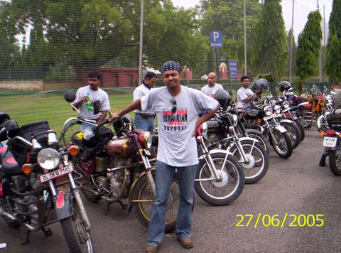
I skip the part of my Mangalore to Delhi journey and my escapades(?!) there. Joined the Odyssey gang on the 26th in Youth Hostel Chanakyapuri where we were given instructions regarding the trip, the rules and regulations (what are those?!!) blah blah... The group consisted 43 bikers from across the country. Three women, two of them riding and one pillion. The next morning the ride started from the National Stadium with the flagging off ceremony done by Sidharta Lal, the CEO of Eicher group. We were instructed to maintain an average speed of 80 kmph during our ride to Chandigarh. So me, like a good guy, started the ride with a constant speed of 80. I slowly realised that I was among of the few last ones in the pack. Even the female riders had overtaken me! To hell with 80 kph! Started ripping and soon was among the leading pack. After some 5-6 hrs of high speed riding, long breaks, we reached our destination for the day, Chandigarh at 3 p.m. where we were put up in Hotel Park View. The distance covered: 250 kms.

The ride next day was the most enjoyable one. About 70 kms from Chandigarh, we took a right turn to hit the ghat roads. Nice winding roads, high speed curves... Riding is an absolute pleasure on the Chandigarh-Manali highway. Passing through Mandi, Bilaspur and after two punctures in my rear tyre and quite a few snaps, we reached Raison (near Manali) where our stay was in an adventure camp beside the Beas. Distance between Chandigarh and Manali: around 330 kms.

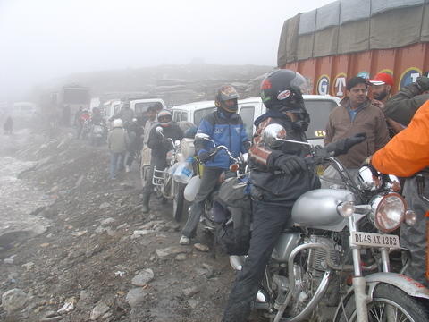
Day 3 and our picnic was over. A major traffic jam near the Rohtang Pass and all the bikers stranded for about 3 hours in near freezing temperature. We tried to make the most of the situation and started throwing snowballs on one another but after sometime the chill factor really got onto us. I started to get a feel of what mountain sickness is. A few river crossings on our way and my feet soaked in chilling water. After about 120 kms of riding, reached Keylong, our day's destination. I was down with fever that night.

Day 4: The riding conditions became worse. I started the day with fever, and soon it was coupled with mountain sickness. I began to lose my mind and integrity. Wider and deeper river crossings, Barachala Pass, everything is hazy in my memory now. Was feeling as though I would drop off the bike anytime. Somehow managed to keep my bike upright and ride to reach Sarchu (107 kms). Nausea, headache, fever, loss of appetite, irritation at anyone, anthing, anywhere..... To make things worse, no sleep that night! That has to be the longest night I've ever spent...


Day 5 was just as worse, though I began to enjoy the landscape around me. Passing Lachulunga, 16500 ft - the highest pass so far, the gorgeous Gata loops with 21 hair pin bends we reached More (pronounced Moray) plains. Plains at a height of about 16500 ft from sea level, surrounded by a chain of white snow-capped mountains! The most beeaauutiful place I've ever been to. Inspite of having acute symptoms of mountain sickness, I could manage to put a smile across my face looking at the landscape around me. Simply mindblowing. And guess what? We were to camp at a place called Debring on the very same More plains that night! To reach the camp, we had to get off road and ride on soft sand which can be tricky. A sooper camping spot. But.... there is a dark side to this place. It turned out to be the most dreadful camps amongst all. Overnight stay at 16500 ft is no joke. I somehow managed to sleep well that night(thankfully), probably coz i didnt have sleep the previous night. Everyone else in the group suffered that night. Hemanth, the guy on the bed next to mine didnt get up the next morning..... He was taken to the nearest military medical camp and then air-lifted to Delhi. He is now safe and sound :-) Distance from Sarchu to Debring: around 125 kms.

Day 6: I seemed to be back to normal after a good night's sleep. Rode to a nearby lake in the morning with a few others and then headed off to Leh (around 150 kms). Very much accustomed to high altitude now, also helped by the fact that we were descending constantly to reach Leh (11000 ft), I began to enjoy the trip. Upshi was the first civilization we got before Leh. From then on, it was a smooth ride to Leh on surprisingly good roads. We were put up in Hotel Lingzhi. Had a nice hot water bath (after 7 days :-) and the only one for the next 7 days also!) and went to sleep, peacefully.

Day 7 was a welcome break for all of us and was spent lazing around Leh. Leh is a serene little town surrounded by snow-capped peaks. The narrow streets are lined with shops owned by Tibetan monks and you can see 'Save Tibet' posters all around. The Tibetans, far away from home, have been surprisingly successful in maintaining their identity here. There are numerous Buddhist monasteries in and around Leh. The main attractions in Leh are the Leh Palace and the Shanti Stupa. The Leh 'Palace' is completely dilapidated and deserted now. The Shanti Stupa is on a hilltop and is tastefully built. Once on top one can enjoy the panoramic view of the chain of mountains around.
Coming back from Shanti Stupa I accidentally noticed an astonishing sight. It was around 6 in the evening and in one direction, only one mountain was gleaming in golden colour! None of the other snow-capped mountains around had that glow. I stood there, speechless!

The next day we were off to do our final conquest: Khardungla! The highest motorable road in the world, at an alititude of 18300 feet. An ascent of about 8000 ft in around 40 kms makes the climb the steepest one. As a pleasant surprise, the weather changed dramatically and we experienced our first snowfall on our way up. Once on top, everyone started doing the victory jig, and we went about hugging anyone and everyone around for the sheer joy of being there with us in our moment of glory! The temperature on top was -4 at 12 noon!


The next morning we started on our return journey on the same route. Due to the weather change, the ride back was considerably tougher. But it made the trip all the more enjoyable. Snowfall, freezing temperature, landslides, numb fingers and toes. Thoroughly enjoyed riding in those conditions! Due to heavy snowfall and landslides, the road got blocked near Bharatpur and we had to spend an additional day in Sarchu. What a day! Doing NOTHING, no connection to the outer world, just lazing around, not feeling guilty of not doing anything. Total bliss, not a care in the world :-). Sadly the road got cleared in a day and the next morning we started off early to avoid getting stuck in a 300-truck traffic jam. What followed was THE toughest stretch of ride one can ever get in a lifetime. 6 o'clock at Baralachala and the water on the road had frozen. Riding on snow is one thing, but riding on plain ice?.... Demands such intense concentration and riding skills that sometimes you stand and wonder 'how do i ride my bike for the next 10 feet?' The sole aim in life seemed to be to keep the bike upright, somehow. Even the rear tyres of the TRUCKS used to sway, seriously! One more stretch of ride on our way back worth mentioning is the ride from Manali to Chandigarh. Some 4-5 500 CCs and me and my friend's 350 CCs rode like maniacs on the ghat stretch. Taking on the curves at more than 100 kmph on that ghat stretch, that was the rashest I've ever ridden. 6-7 Bullets on the rampage like that, every other vehicle on the road would just make way for us. We owned the roads... as we headed back to our final destination: Delhi.

There is no better way to experience the Himalayas than on bikes. The blissful feeling you get when you stop the bike to look out into the valley far down below the road or the narrow winding roads in front of you is priceless. Certain places all we could see was the blue sky, 360 degrees of snow and a trail of tarmac in front of us. Nothing else! That was a sight to remember..... Although have been to a trek in the Himalayas after the ride, the mountain ranges are calling me, again. And I have to go. It's only a matter of time before I start off for another Himalayan expedition.....

The photos of the trip are here

Thus continues the quest...